January 12, 2026
Alberta Real Estate Foundation Blog Post: Supporting Environmental Outcomes in Rural Municipal Development Planning
By Miistakis Institute
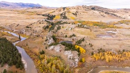
In southern Alberta, scenic landscapes, agricultural lands, and recreational opportunities are key drivers of the rural real estate market. These characteristics are sustained by strong ecological connectivity, which facilitates the flow of natural processes through a connected landscape. However, rural municipalities are faced with balancing protection of ecological connectivity with growth, as residential development, resource extraction, infrastructure, and recreation continue to expand. With support from the Alberta Real Estate Foundation, Miistakis is working with municipal planners to translate existing science into practical planning tools and policies that support sustainable development while maintaining community values.
Planning for Ecological Connectivity
Practical planning resources help to translate ecological science into planning and decision-making. The Wildlife Movement Tool is an online mapping tool developed to assess whether and how a proposed new development within or adjacent to an ecological corridor may affect medium to large mammal movement, and provides strategies to mitigate for negative impacts identified by the tool. Its results are intended to support informed, consistent decision-making across planning and approval processes, including development permits, subdivision applications, and rezoning reviews. It is also a tool that can be used directly by a developer. The Wildlife Movement Tool currently supports assessments in the Crowsnest Pass and Pincher Creek, where corridors have been delineated, however can be expanded to other municipalities.
The Development Mitigation Guidelines for Ecological Corridors document complements the Wildlife Movement Tool by outlining mitigation strategies aligned with potential corridor impacts. Designed for developers and municipal decision makers, the guidelines support flexible solutions that balance development needs with the protection of ecological connectivity.
In addition to integrating ecological connectivity into existing high-level planning policy such as Municipal Development Plans, new planning tools are needed to support implementation. Working with the Oldman River Regional Services Commission, Miistakis developed Ecological Corridor Overlay: Recommendations for Implementation in Rural Municipalities, which provides sample language and guidance for applying an overlay district in municipal zoning. An ecological corridor overlay district would create a set of criteria and requirements that exist within the boundary of a mapped ecological corridor that supplements the rules of the underlying zone. Informed by a workshop with planning practitioners, the document offers municipalities a flexible, ready-to-use reference that can be adopted when local timing and interest allows.
Making Wildlife Movement Visible in Pincher Creek
To expand the tool to be used in additional rural municipalities, we must understand where connectivity still exists and agree on the priority areas to protect. Miistakis delineated an ecological network for the Municipal District of Pincher Creek, based on ecological flow of remaining natural habitat, to identify where connectivity remains and where it is most at risk. This spatial reference was developed in partnership with planners and local experts and provides a practical tool to guide growth and development in areas that are appropriate, and away from areas that will eliminate or degrade ecological connectivity.
Looking ahead: Corridor Conservation Action Strategy
To support implementation of the Pincher Creek ecological network into planning and policy, we developed the Pincher Creek Ecological Corridor Conservation Action Strategy, which provides a shared, practical framework for land managers and decision makers. It identifies context-specific corridor conservation actions based on land ownership, management responsibilities, and land-use designations, and will be released in early 2026.
Overall, this project advances the real estate industry by supporting municipalities and developers with practical planning tools that integrate ecological connectivity into land-use decision making. By guiding development in ways that protect the environmental amenities that attract investment, such as clean water, scenic landscapes, and recreation, this project helps to ensure long-term property value, market stability, and sustainable growth in rural Alberta communities. Thank you to the Alberta Real Estate Foundation for supporting this work.
Contributor
Miistakis Institute
The Miistakis Institute specializes in evaluating complex environmental problems and using our equally diverse skill sets and tools to resolve them.
Similar News